HOLT, Fla., April 9, 2024—Conditions are setting up for another severe weather threat across the region tomorrow afternoon into the evening.
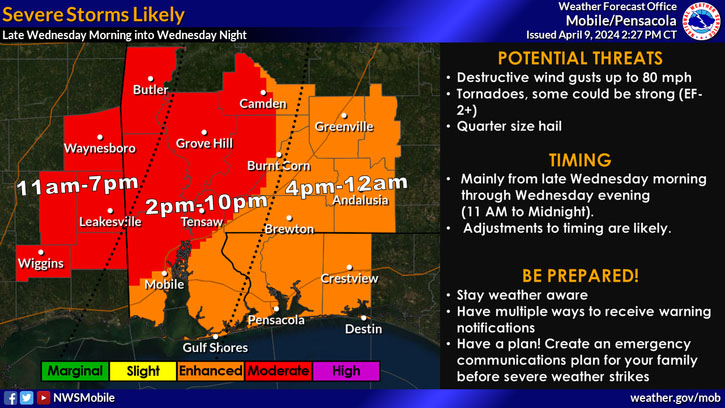
The entire northwest Florida area is in a level 3 out of 5 risk with damaging wind gusts, strong tornadoes and hail possible.
Level 4 activity is setting up just to the west of the Interstate 65 corridor in Alabama.
Destructive wind gusts up to 80 mph, strong EF2-plus tornadoes, quarter-sized hail and heavy rain are possible.
Due to the forecast, Okaloosa County schools will dismiss one hour earlier than their regular release times tomorrow. Baker School will dismiss at 1:30 p.m., according to the school district.
Additionally, all after-school activities, including tutoring, athletics and daycare are canceled.

Windy conditions are expected to develop outside of any thunderstorm activity tomorrow and a wind advisory is in effect from 11 a.m. to 8 p.m. tomorrow with 20-30 mph wind and gusts up to 45 mph.
Updated timing for the severe weather here is forecast to occur between 4 p.m. tomorrow to 1 a.m. Thursday. Although the forecast calls for the main threats to be over by midnight, they could linger until 2 a.m. Thursday, according to the National Weather service.
Although the forecast calls for widespread rainfall of 2-4 inches, localized totals of 6-8 inches are possible. Intense rainfall totals in a short time frame can cause area flash flooding. Minor river flooding is also a possibility, according to the NWS.
A cold front passing through the area behind the severe weather will bring drier conditions for Thursday into next week.
NWS forecast
