HOLT, Fla., May 9, 2024—Another active weather day is on tap for today with multiple rounds of severe thunderstorm activity through tomorrow morning.
The National Weather Service has updated the forecast to include the northern half of the northwest Florida panhandle in a level 3 risk for severe weather tonight and tomorrow.

According to NWS Mobile, the first round of level 2 storms will likely occur later this morning through early afternoon, between 10 a.m. to 3 p.m. Timing for north Okaloosa County could be on the back end of that timeframe.
Although the number of storms, if any, is uncertain, atmospheric conditions mean any that do develop could contain damaging winds, hail up to golf ball size and a potential tornado.
A second round of thunderstorms will likely be more significant, according to the NWS.
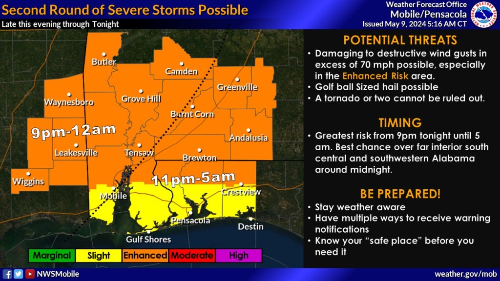
The forecast calls for a cluster of storms to move east across most of the area around midnight.
Confidence is increasing that this system will contain damaging straight-line winds as the primary threat. Heavy rain can also be expected.
Finally, a third round of storms will depend on how much the storms from round two disturbs the atmosphere. If storms do occur, they could bring large hail, according to the NWS.
Primary risks for these storms is destructive wind gusts in excess of 70 mph, golf ball-sized hail and a possible tornado or two.
Timing for these rounds is forecast to be begin later this evening and continue into tomorrow morning, between 11 p.m. tonight to 5 a.m. tomorrow.
