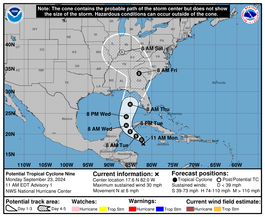
HOLT, Fla., Sept. 23, 2024—The National Hurricane Center is now identifying the Invest 97 in the Caribbean Sea as Potential Tropical Cyclone Nine.
Interests along the northeastern Gulf Coast, including the Florida Panhandle and portions of the Florida west coast, should monitor the progress of this system, according to the NHC.
The disturbance is forecast to strengthen and be near hurricane strength when it reaches the far northwestern Caribbean Sea tomorrow night.
PTC9 is forecast to become Hurricane Helene Wednesday and could be a major hurricane by the time it reaches the northeastern Gulf Coast Thursday.
According to the NHC, the initial motion is uncertain given the current lack of organization. However, a gradual turn toward the northwest is expected during the next day or so, with the center passing through the Yucatan Channel and into the southern Gulf of Mexico.
After that, the system is forecast to accelerate northward across the eastern Gulf of Mexico.
This motion should bring the center of the system toward the northeastern Gulf Coast Thursday.
The disturbance lacks a well-defined center making the average forecast track uncertainty larger; future track adjustments may be required.
Given the large size of the tropical-storm-force wind field and fast forward speed that is forecast, storm surge, wind and rainfall impacts will likely extend well away from the center, particularly to the east of the system.
While the system is currently broad and not well organized, models suggest a more well-defined center should develop during the next day or so.
Once the system becomes better organized and develops an inner core, the environmental and oceanic conditions appear favorable for significant strengthening.
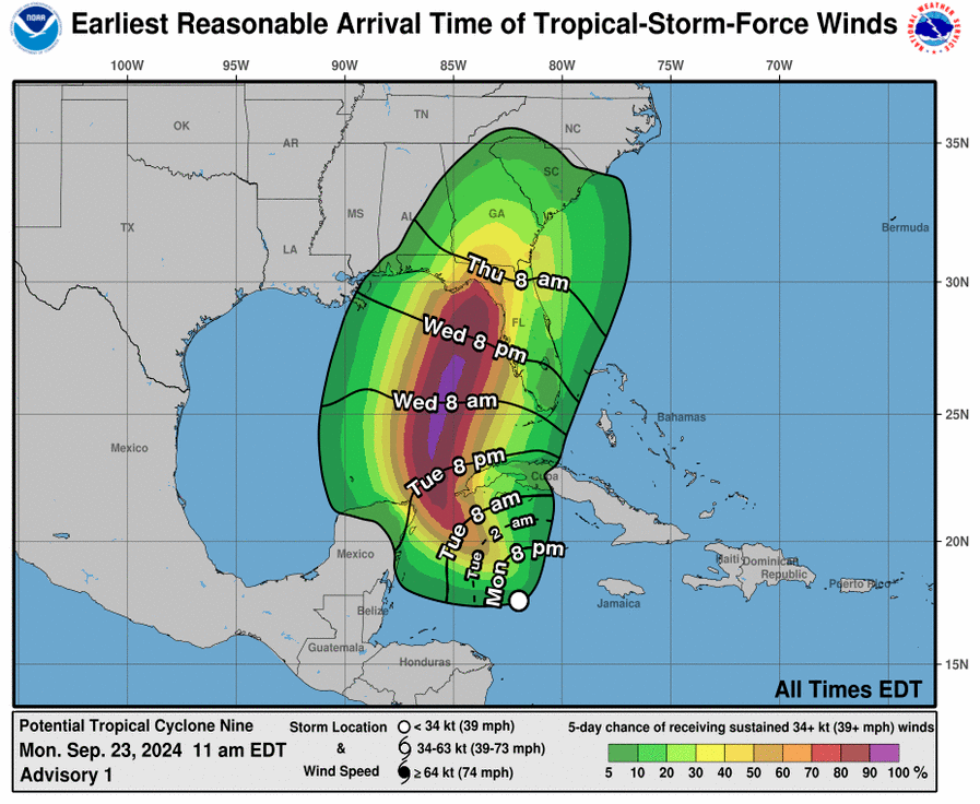
There is an increasing risk of life-threatening storm surge and damaging hurricane-force winds along portions of the northern and northeastern Gulf Coast, including the Florida Panhandle and portions of the Florida west coast.
An Air Force Reserve reconnaissance aircraft is scheduled to investigate the system this afternoon.
Although it is too soon to specify the exact location and magnitude of impacts, residents in these areas should monitor the latest forecast updates.
Okaloosa County is making sand and sandbags available beginning at noon today until the threat of the storm is gone.
North Okaloosa County location is Public Works North, 1759 S. Ferdon Blvd in Crestview. Enter on the Goodwin Avenue side. Sandbags are intended for residents and are not intended for commercial use.
Staff and National Hurricane Center forecast

Pingback: Okaloosa County under state of emergency | Holt Enterprise News