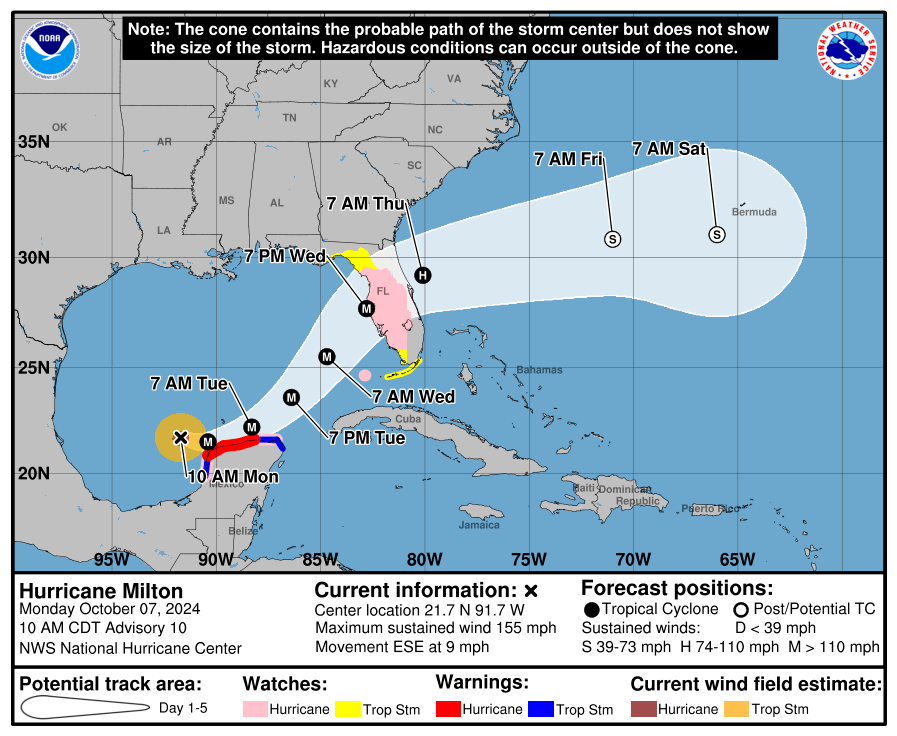
HOLT, Fla., Oct. 7, 2024—Milton is now a category 4 storm and is expected to continue to intensify as it approaches the west coast of Florida.
According to the National Hurricane Center, Milton is an extremely dangerous storm with 155 mph winds and is forecast to intensify to a category 5 storm later today and reach a peak of 165 mph in the next 12 hours.
Although a small storm, eyewall replacement cycles will likely cause the system to gradually weaken but grow larger, according to the NHC.
After 36 hours, Milton is forecast to encounter a less favorable environment with strong wind shear and dry air resulting in some weakening before it reaches the Florida west coast.
Hurricane watches are now in effect along the west coast from Chokoloskee, south of Everglades City, to the mouth of the Suwanee River and includes Tampa Bay. Areas inland across the peninsula are also under a hurricane warning.
Tropical storm watches are in effect along the west coast and inland from Flamingo to south of Chokoloskee, including the Florida Keys, and north of the mouth of the Suwanee River to Indian Pass, south of Port St. Joe.
Areas of heavy rain will impact portions of Florida today well ahead of Milton, with heavy rainfall more directly related to the system expected later tomorrow through Wednesday, according to the NHC.
Rainfall amounts of 5-10 inches, with localized totals up to 15 inches, are expected across portions of the Florida Peninsula and the Keys through Wednesday night.
The NHC’s message about storm surge:
“The combination of a dangerous storm surge and the tide will cause normally dry areas near the coast to be flooded by rising waters moving inland from the shoreline. Near the coast, the surge will be accompanied by large and destructive waves.
“The deepest water will occur along the immediate coast near and to the south of the landfall location, where the surge will be accompanied by large and dangerous waves. Surge-related flooding depends on the relative timing of the surge and the tidal cycle, and can vary greatly over short distances.
“Water could reach the following heights above ground somewhere in the indicated areas if the peak surge occurs at the time of high tide.”

National Hurricane Center forecast
