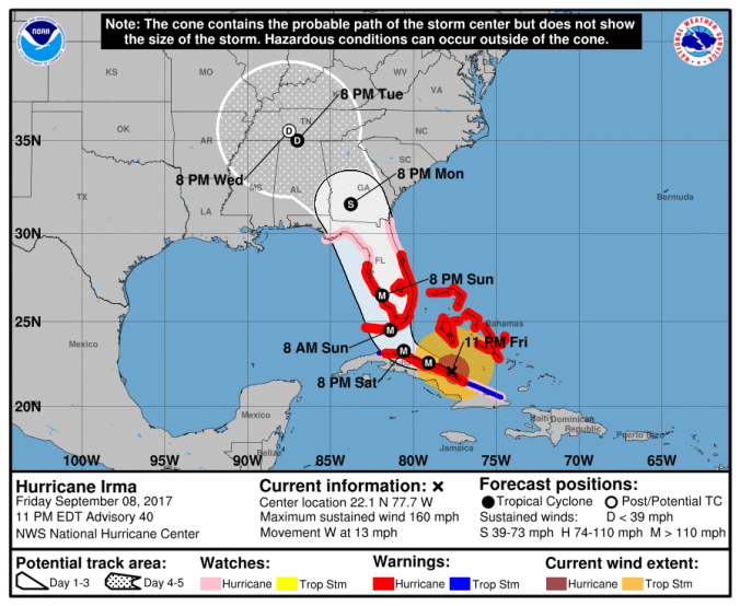
HOLT, Fla., Sept. 8, 2017, 10 p.m. CDT–The National Hurricane Center extended Hurricane Irma’s three-day cone of probability up into southern Georgia and shifted the track slightly westward at its 11 p.m. update.
Additionally, the center upgraded Hurricane Irma to a category five storm based on Hurricane Hunter information.
Hurricane watches now include the Big Bend area of the panhandle’s coast, including Apalachicola.
Strengthening
An Air Force Reserve Hurricane Hunter flight measured winds at 177 mph and a 40-mile-wide eye. Generally, the tighter the eye, the stronger the storm.
If the eye continues to move over the Cuban Keys and does not move inland over the main island of Cuba, Irma would likely not lose much intensity during the next day or so.
However, there are some indications wind shear may increase over the hurricane, creating a little more weakening.
Direction
Because the eye is still on its westward path, the NHC shifted the track again slightly westward.
Irma is still expected to turn west-northwest soon as it moves along the Cuban Keys next to the north coast of Cuba through Saturday, near the Florida Keys Sunday morning and then near the southwest coast of Florida Sunday afternoon.
Because of the hurricane’s angle of approach to Florida’s west coast, it is extremely difficult to pinpoint exactly where the center will make landfall, according to the NHC.
Additionally, Irma would be able to maintain a strong intensity for a longer period of time if the center stays off the west Florida coast.
