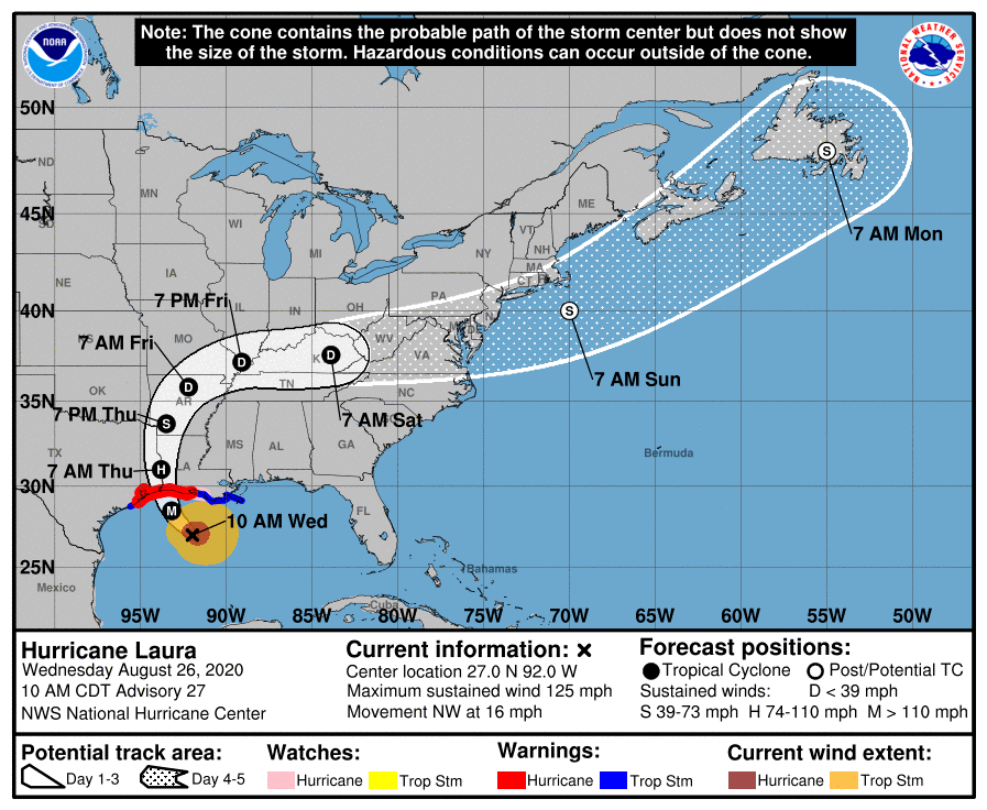
HOLT, Fla., Aug. 26, 2020—The National Hurricane Center is forecasting Laura to become a category 4 storm today.
Catastrophic storm surge, extreme winds and flash flooding are expected along the northwest Gulf coast tonight, according to the NHC.
Laura is the first major hurricane in the Gulf of Mexico during the month of August since Harvey in 2017.
Currently packing winds near 125 mph, the hurricane strengthened 46 mph in a 24-hour period to a category 3 storm by 7 a.m. this morning.

Laura is a dangerous category 3 hurricane on the Saffir-Simpson Hurricane Scale and is forecast to continue strengthening into a category 4 hurricane with 145 mph winds this afternoon as it moves over warm Gulf waters, according to the NHC.
An anticipated increase in wind shear around the time of landfall may reduce the storm’s intensity; however, Laura is forecast to remain an extremely powerful category 4 hurricane.
Laura will weaken rapidly after landfall, according to the NHC, but it will likely bring hurricane-force winds well inland over western Louisiana and eastern Texas.
Texas and Louisiana have initiated mandatory evacuations in coastal communities.
The extended-range forecast indicates there’s a chance Laura could re-intensify as a tropical cyclone off the Mid-Atlantic coast.
Effects of Laura
Laura is a large hurricane with hurricane-force winds extending outward up to 70 miles from the center and tropical-storm-force winds outward up to 175 miles.

Wind, storm surge and rainfall hazards will extend far from the center.
Once it makes landfall, Laura will continue to affect areas in Louisiana, Texas, Arkansas and into the middle-Mississippi, lower Ohio and Tennessee valleys Friday night and Saturday.
Life-threatening storm surge with large and dangerous waves is expected to produce potentially catastrophic damage from San Luis Pass, Texas, to the mouth of the Mississippi River, including areas inside the Port Arthur Hurricane Flood Protection system, according to the NHC.
This surge could penetrate up to 30 miles inland from the immediate coastline in southwestern Louisiana and southeastern Texas.
Hurricane-force winds and widespread damaging wind gusts are also expected to spread well inland into portions of eastern Texas and western Louisiana early Thursday.
Widespread flash flooding along small streams, urban areas and roadways is expected to begin this afternoon into Thursday from far eastern Texas, across Louisiana and Arkansas.
National Hurricane Center forecast
