
HOLT, Fla., Sept. 10, 2021—Welcome to the peak of the 2021 Atlantic hurricane season.
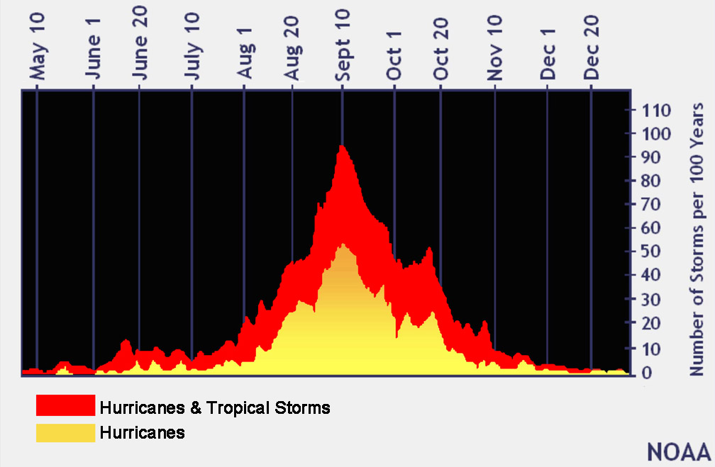
With a six-month hurricane season that begins June 1, the end of August is the mid-point; however, Sept. 10 is considered the climatological peak of the Atlantic Basin, which includes the Atlantic Ocean, the Caribbean Sea and the Gulf of Mexico.
And while reaching Sept. 10 may seem like hitting a milestone, a secondary season peak of tropical activity occurs mid-October for areas in the Caribbean and Gulf.
Historically, after the second peak, the number of storms drops off.
This time last year, the National Hurricane Center was watching seven areas of interest: Tropical storms Paulette and Rene, four tropical waves and waiting for a fifth wave to develop off the coast of Africa.
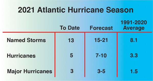
Forecasters predicted an above-average season, the sixth since 2016, with 15-to-21 named storms and 7-to-10 hurricanes. Of those, three-to-five were predicted to become major hurricanes.
To date, there have been 13 named storms, five hurricanes and three major hurricanes.
Looking at the predictions, that means there are at least two more named storms and two more hurricanes to reach the lower end of the prediction spread.
With three more months left in the season, it’s a good bet there will be more named storms and another hurricane or two—at least.
So far, there have been seven storm landfalls in the United States this year: tropical storms Claudette and Danny, Hurricane Elsa, TS Fred, hurricanes Henri and Ida, and TS Mindy.
Currently, the National Hurricane Center is watching two waves on opposite ends of the Atlantic Basin.
A strong tropical wave is expected to move off the coast of Africa this evening and gradually develop.
A tropical depression is likely to form late this weekend or early next week as the system moves west-northwest.
Closer to home, a second tropical wave is forecast to move into the Bay of Campeche, Mexico.
Conditions are favorable to support gradual development and a tropical depression is likely Sunday or Monday before the system moves onshore along the western Gulf coast.
Both have a 70 percent chance of development.
Meanwhile, Hurricane Larry, now a category 1 storm, is forecast to make landfall over southeastern Newfoundland tonight.
