HOLT, Fla., March 29, 2022— A significant severe weather outbreak is expected across the local area late tomorrow afternoon through tomorrow night.
The National Weather Service has upgraded the severe storm risk for the entire Mobile forecast area to a level 4 out of 5.
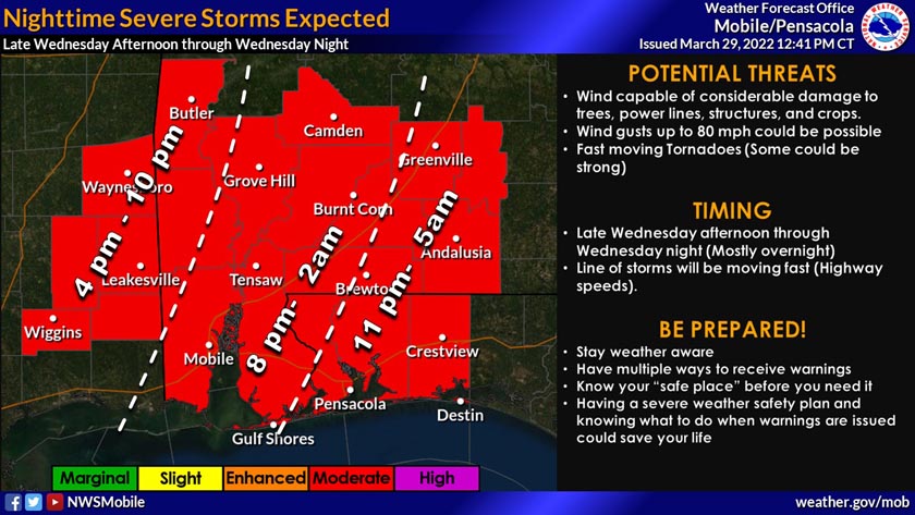
A line of severe thunderstorms will develop to the west and strengthen Wednesday afternoon as it moves across Mississippi. This line will likely move into southeast Mississippi counties during the late afternoon and evening, and across the remainder of the area through early Thursday morning, according to the NWS.
This line of storms will be moving fast, at near highway speeds, according to the NWS.
Timing for Northwest Florida storms is a 12-hour window beginning around 6 p.m. tomorrow to 6 a.m. Thursday, with Okaloosa County seeing the bad weather between 11 p.m. to 5 a.m.
All modes of severe weather is possible: heavy rain, flash flooding, damaging winds, large hail and tornadoes.
Numerous episodes of damaging winds with gusts up to 80 mph are expected which could cause considerable damage to trees, power lines, structures and crops.
Several fast-moving tornadoes, some possibly strong EF2 or greater, are also possible, as well as destructive hail 2” in diameter or greater.
Well ahead of the front tomorrow, strong southerly winds will develop with sustained speeds of 25 to 30 mph with frequent gusts of 50 to 55 mph. This could cause instances of non-thunderstorm damage.
To that end, a wind advisory will be in effect from 10 a.m. to midnight tomorrow.
RedZone Weather

In the event of a tornado warning, meteorologist Spinks Megginson of RedZone Weather, will be live on Facebook (@rzweather). A former Birmingham TV weekend weather anchor, Megginson now operates RedZone Weather from Brewton, Ala., where he covers local weather in southern Alabama and northwest Florida.
Throughout his life Facebook feeds during tornado warnings, Megginson not only identifies the communities immediately affected, but he calls out warnings in real time for those areas within the possible path.
