 HOLT, Fla., March 25, 2018–The National Weather Service in Mobile is expecting heavy rainfall associated with the first storm system of the 2018 hurricane season.
Thunderstorm activity associated with the low-pressure system has increased and become better organized, according to the National Hurricane Center.
Becoming better defined overnight, the system is beginning to move off the Yucatan Peninsula over the northwestern Caribbean Sea.
As the system moves into the Gulf of Mexico, environmental conditions are forecast to steadily become more favorable for development.
A subtropical or tropical depression or storm is likely to form by Saturday over the southeastern Gulf of Mexico, according to the NHC.
An Air Force Reserve reconnaissance aircraft is scheduled to investigate the low this afternoon.
Locally heavy rainfall is forecast across much of Florida and the northern Gulf Coast into early next week.
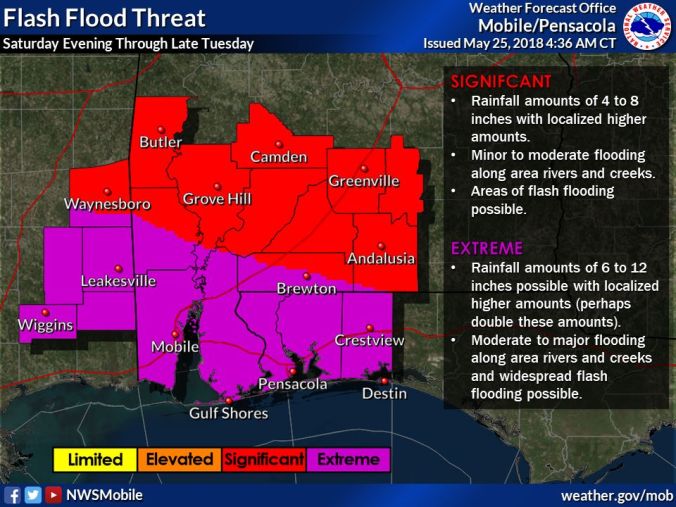 The NWS in Mobile forecasts multiple days of heavy rainfall starting Saturday associated with the storm.
The NWS expects this system to bring excessive rainfall likely causing flash flooding.
Rainfall amounts of 6-to-12 inches with localized heavier amounts or more is possible.
 A flash flood watch is in effect Saturday evening through Tuesday evening.
This system could bring subtropical-storm-force winds and storm surge to portions of the northern Gulf Coast by late this weekend or early next week.
Additionally, coastal hazards include life-threatening rip currents through Monday night and high surf of 5 feet or higher Saturday afternoon to Tuesday evening.
Coastal flooding of 2-to-4 feet inundation along low-lying areas of the coast, bays and sounds during period of high tide is possible.
Formation chance of further development remains high at 90 percent.
NWS Mobile and National Hurricane Center forecast
