 HOLT, Fla., Aug. 29, 2019—Florida’s governor extended yesterday’s state of emergency for the entire state today.
“Due to Hurricane Dorian’s uncertain projected path, I am expanding the state of emergency to include all 67 counties throughout Florida,” said Governor DeSantis. “All residents, especially those along the east coast, need to be prepared for possible impacts. As it increases strength, this storm has the potential to severely damage homes, businesses and buildings, which is why all Floridians should remain vigilant. Do not wait until it is too late to make a plan.”
A declared state of emergency provides state and local governments time, resources and flexibility to prepare as the exact landfall location of the hurricane continues to fluctuate.
Florida is not under any watches or warnings, evacuation orders or school closings and the western panhandle is not in the forecast cone at this time.
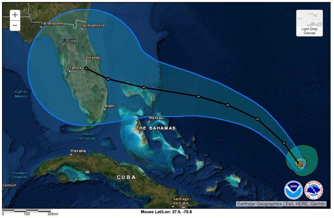
The hurricane is moving northwest at 13 mph and should continue that motion into tonight, moving through a favorable environment of low wind shear and warm waters. This will allow for a steady intensification, according to the National Hurricane Center.
The hurricane center warns Dorian is expected to become a major hurricane tomorrow and remain extremely dangerous through Labor Day weekend.
Tomorrow, Dorian is forecast to turn west-northwest with a west-northwest to west movement motion into the weekend as the storm approaches Florida’s eastern coast.
 The NHC reminds people not to focus on the exact forecast track (the center of the cone) because typical forecast errors at day four and five can differ between 155-to-205 miles, respectively.
In other words, Dorian could make landfall anywhere within the cone of uncertainty.
Maximum sustained winds are still forecast to be 130 mph, a category 4 hurricane.
There is an increasing likelihood of life-threatening storm surge and devastating hurricane-force winds along portions of Florida’s east coast late this weekend or early next week, though it is too soon to determine where the highest surge or strongest winds will occur.
An estimated f-to-10 inches of heavy rains with isolated areas receiving 15 inches is expected this weekend and into the middle of next week.

