 HOLT, Fla., Aug. 30, 2019—The National Hurricane Center expects Hurricane Dorian to become a major category 3 hurricane sometime today.
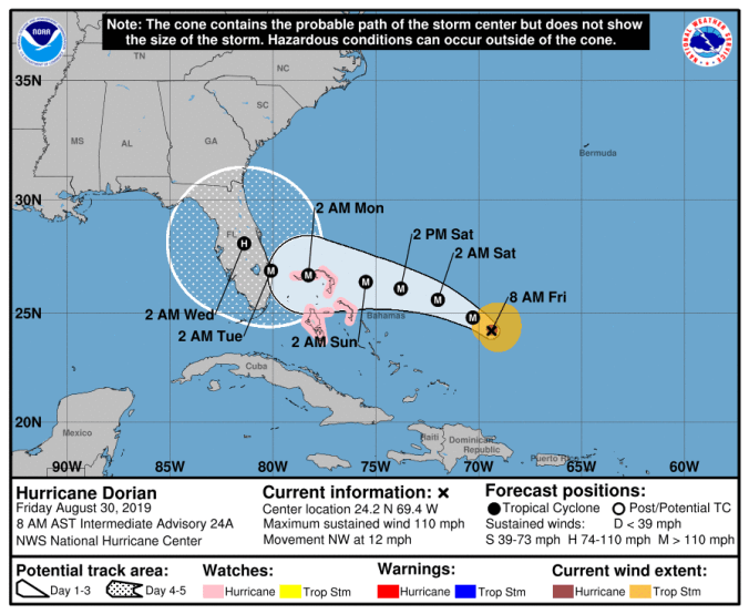
Dorian is expected to remain an extremely dangerous hurricane as it moves closer to the southeast Florida coast, according to the NHC.
Today’s forecast shows the storm’s strength projections increased to 140 mph winds at landfall.
Data from an Air Force Reserve reconnaissance aircraft indicate maximum sustained winds have increased to near 110 mph, currently making Dorian a strong category 2 storm.
The hurricane slowed down just a bit, moving toward the northwest near 12 mph and will likely slow down considerably as it approaches the Florida peninsula, according to the NHC.
A slower west-northwest to west motion should begin tonight through the weekend, according to the forecast.
Dorian is expected to begin turning northwest to north at some point during the next five days, but forecasters are uncertain exactly when and where that will happen.
 Because of the uncertainty of an exact landfall location, forecasters are cautioning people not to focus on the centerline track of the cone. Landfall could occur anywhere in the cone of uncertainty which includes the entire east coast of Florida at this time.
Dorian’s large size means hurricane impacts will be felt throughout the peninsula regardless of landfall location.
According to the NHC, the biggest concern will be Dorian’s slow motion when it’s near Florida, placing some areas of the state at an increased risk of a prolonged, drawn-out event of strong winds, heavy rainfall and life-threatening storm surge combined with high tides, that could last for a couple of days next week.
Florida’s east coast is currently experiencing a period of extremely high tides, also known as king tides. This period is expected to last through Tuesday when Dorian is forecast to make landfall somewhere along the southeast coast.

