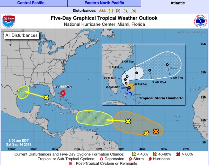
National Hurricane Center shows lots of tropical activity in the Atlantic Sept. 14.
HOLT, Fla., Sept. 14, 2019—Overnight developments in the Atlantic basin have provided a number of tropical areas to keep an eye on for the next few days.
In the Gulf of Mexico, a large area of showers and thunderstorms over the eastern Gulf is primarily associated with a upper-level low pressure area.
Only slow development of this system is likely during the next couple of days, according to the National Hurricane Center.
However, conditions could become more favorable for development early next week as the system moves over the western Gulf of Mexico.
For now, the NHC gives this a 30 percent chance of developing.
A fast-moving tropical wave located about 950 miles east of the Lesser Antilles is producing limited shower activity.
Significant development of this system is not anticipated during the next several days while it moves quickly westward, according to the NHC.
It only has a 10 percent chance of development for now.
An elongated area of disturbed weather is located about 650 miles southwest of the Cabo Verde Islands.
Gradual development of this system is possible during the next several days and a tropical depression could form early next week while it moves westward across the tropical Atlantic.
The NHC gives this system a 60 percent chance of formation.
And the area of disturbed weather located midway between the Lesser Antilles and the Cabo Verde Islands merged with the easternmost tropical wave mentioned above.
Finally, Tropical Depression Nine gained strength to become Tropical Storm Humberto by the NHC’s 11 p.m. tropics update last night.
It’s forecast to reach category 1 hurricane strength in the next couple of days and is projected to turn northeast away from the United States toward Bermuda.
NHC forecast
