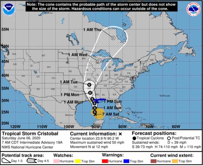
 HOLT, Fla., June 6, 2020—Tropical Storm Cristobal is expected to slowly strengthen until it makes landfall in a couple of days.
However, the broad structure of the storm, dry air and moderate wind shear should prevent a significant amount of intensification, according to the National Hurricane Center.
Maximum sustained winds are near 50 mph with higher gusts.
For now, the forecast is for Cristobal to remain a mid-level tropical storm with maximum winds at 60 mph before landfall.
 Satellite imagery this morning shows Cristobal does not have a classic tropical storm structure, but is elongated north-south, pushing most of the system east of the center.
Therefore, the NHC urges to not focus on the exact forecast path because associated winds, storm surge and rainfall will extend well east of the center.
Tropical-storm-force winds will arrive well in advance of and extend well east of Cristobal’s center, according to the NHC.
 These winds are expected by late Saturday night along the northern Gulf coast and are possible along portions of the western Florida panhandle from late Saturday night through early Monday morning.
At 7 a.m., the center of TS Cristobal was located over the Gulf of Mexico about 365 miles south of the mouth of the Mississippi River.
It’s moving toward the north near 12 mph.
Around landfall time, a slight turn to the northwest is expected. This motion should take the center of the storm across the Louisiana coast by Sunday night.
The center of Cristobal will move northward over the central Gulf of Mexico today, be near the northern Gulf of Mexico coast Sunday and move inland across Louisiana late Sunday and Monday morning.
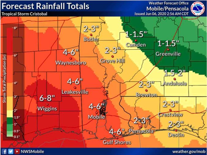 Heavy rainfall will spread into portions of the Gulf Coast, from east Texas to Florida, this weekend into early next week,
Rainfall amounts between 3 and 6 inches are expected along and south of the Interstate 10 corridor, with isolated higher amounts.
 A few tornadoes will also be possible from Sunday through Monday morning along and south of I-10.
