HOLT, Fla., Aug. 8, 2021—The National Hurricane Center is monitoring three areas of disturbed weather in the Atlantic ocean.
Two of the three have potential to develop into tropical depressions.
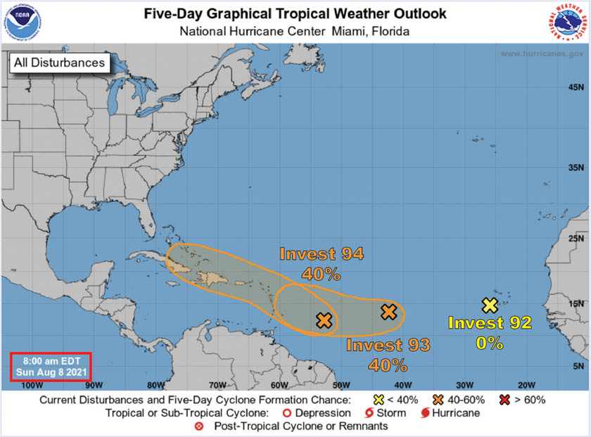
First, the tropical low that moved off the coast of Africa earlier this week identified as Invest 92, is now in cooler waters with upper-level winds that will prevent further development of this system.
This area has a zero chance of development and will likely not be identified on the 2 p.m. NHC update.
A second low pressure area in the mid-Atlantic, now identified as Invest 93, has become more concentrated since yesterday, according to the NHC.
Environmental conditions are expected to become a little more favorable for gradual development as it slowly move toward the west-southwest or west.
At 40 percent, this system could become a tropical depression within the next few days.
The third system located west of the Windward Islands, is now identified as Invest 94.
Environmental conditions are favorable to support some development and it could become a tropical depression while it moves west-northwest, according to the NHC.
Invest 94 is forecast to move across the eastern Caribbean Sea through the middle of this week.
It also has a 40 percent chance of further formation.
If one of these two systems develops into a tropical storm, it will be named Fred. After Fred, Grace is the next name on the hurricane list.
National Hurricane Center forecasts
