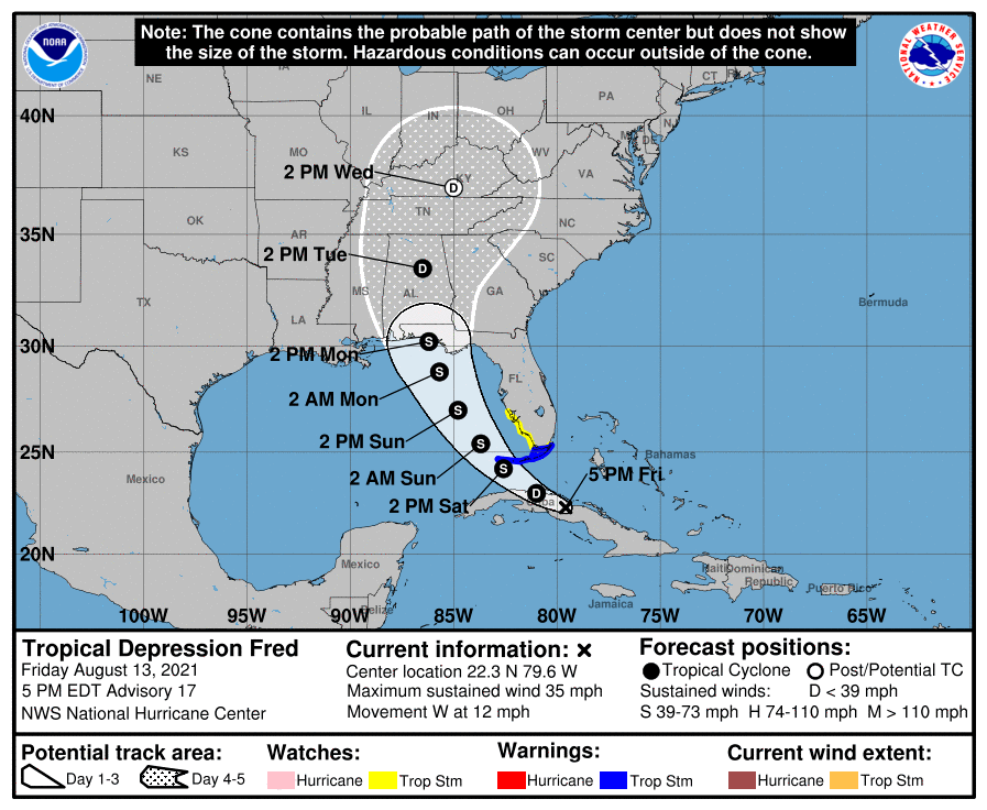

HOLT, Fla., Aug. 13, 2021—There is a risk of tropical storm conditions here Sunday and Monday as Fred makes its way toward the northwest Florida panhandle.
The latest National Hurricane Center forecast track shows a westward shift, putting Okaloosa and Walton counties in the center of the cone.
Some additional westward adjustments may be necessary until the track guidance stabilizes, according to the NHC.
A tropical depression for now, Fred is forecast to regain tropical storm strength during the next 24 hours.
Tropical storm watches and warnings are likely this weekend.
Moving west near 12 mph, Fred is forecast to turn west-northwest tonight and then northwest tomorrow.
Fred remains a disorganized tropical depression, according to the NHC.
However, as Fred tries to organize, a center re-formation could occur tomorrow near the north coast of Cuba or over the Straits of Florida as the system moves over warm Gulf waters, according to the center.
Since it will take time for the system to recover after its passage over Cuba, only gradual strengthening is indicated during the next day.
Fred remains within an area of moderate southwesterly vertical wind shear and the model guidance generally indicates this will continue during the next day or so, according to the NHC.
After that time, the system could be in a somewhat more favorable environment, and the NHC intensity forecast calls for some strengthening until Fred reaches the northern Gulf Coast, which now doesn’t occur until sometime Sunday with the wider turn shown in the track forecast.
It’s still too early to determine where Fred will make landfall.
The NHC reminds viewers not to focus on the exact forecast track as heavy rainfall, gusty winds and a chance of tornadoes will extend far to northeast and east of the center of the system.
