
HOLT, Fla., March 20, 2022—Another significant severe weather event could impact much of the forecast area Tuesday.
According to the National Weather Service’s Storm Prediction Center, another round of severe storms with heavy rainfall is looking likely Tuesday afternoon and into the evening and possibly lingering across the eastern part of the forecast area through late Tuesday night.
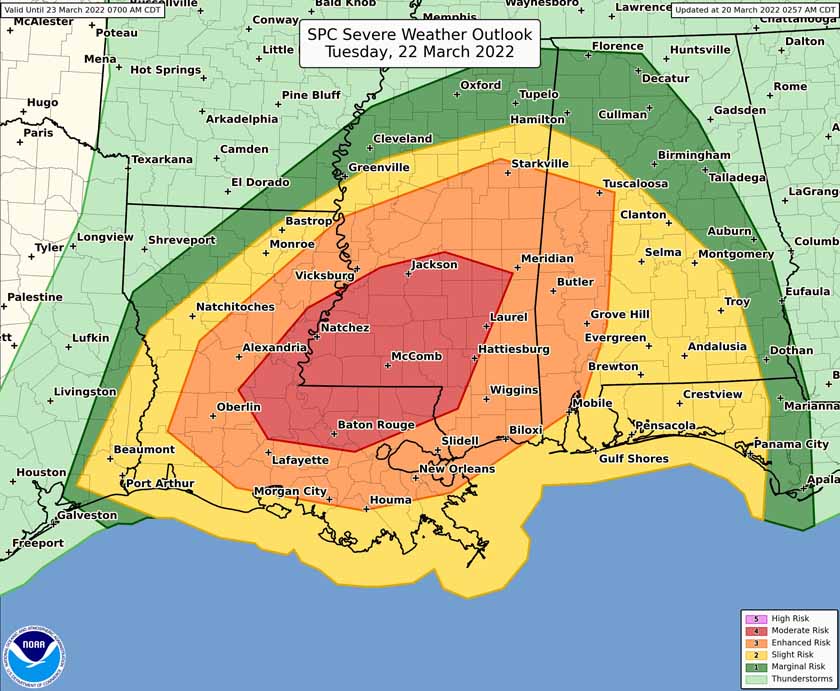
As of today, this area will be under a level 2 out of 5 risk for severe storms. The risk increases to the west with western Alabama and eastern Mississippi under a level 3. Further west in Mississippi and Louisiana, the risk increases to a level 4.
Dry weather and sunny skies since Friday’s storms will give way to Gulf moisture gradually working its way back into the local area tomorrow. That coupled with rising temperatures could increase the risk level here during the next couple of days leading into Tuesday.
Heavy rainfall is looking likely with this next event, with some areas potentially receiving in excess of 2-3 inches of rain within a fairly short amount of time, according to the NWS.
A damaging straight-line wind threat (70+ mph) and tornadoes, a few of which could become strong, are also possible again Tuesday.
Strong southerly winds outside of the storm system are forecast to develop, with the potential for sustained wind speeds up to around 20-30 mph and frequent gusts of 35-45 mph. A wind advisory will likely become necessary Tuesday.
The NWS stresses everyone to have a severe weather safety/preparedness plan ready and also to have multiple ways of receiving warning information ahead of Tuesday’s storms.
Staff and NWS forecast
