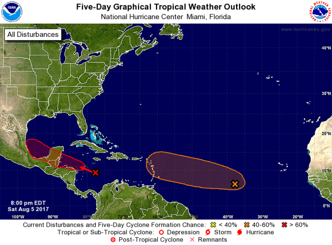
The Atlantic system has weakened while the Caribbean system has gained potential for further development. (image courtesy National Hurricane Center)
HOLT, Fla., Aug. 5, 2017–The two tropical waves have switched places in regards to development potential.
The National Hurricane Center downgraded the system languishing in the Atlantic Ocean by giving it a 50 percent chance of formation during the next five days. Moderate-to-strong wind shear north of the low’s center is limiting the system’s further development.
Located about 1,000 miles west-southwest of the Cabo Verde Islands, the system is moving about 15 mph. It’s expected to encounter less-favorable conditions during the middle part of next week.
Meanwhile, while attention was focused on the potentially stronger Atlantic system that hasn’t developed, the system in the Caribbean now shows some potential to develop into a tropical depression, according to the NHC.
Describing it as a “strong tropical wave,” the NHC forecasts “a tropical depression or tropical storm could form over the northwestern Caribbean Sea before it reaches the Yucatan peninsula late Monday or Tuesday. ”
If it doesn’t become a tropical depression before reaching the Yucatan, it could further develop while crossing the Bay of Campeche during the middle part of next week.
Hurricane models show the system staying on its west-northwestward track across southern Mexico. It’s currently traveling at 10 to 15 mph.
Formation chance for this system through the next five days is now at 70 percent.
An Air Force Reserve reconnaissance aircraft is scheduled to investigate this system tomorrow afternoon, if necessary.

Hurricane models for the tropical wave in the Caribbean Sea show it moving across southern Mexico. (image courtesy South Florida Water Management District)
