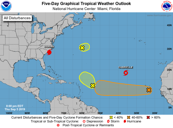
 HOLT, Fla., Sept. 5, 2019—Yet a third low-pressure area popped up on the National Hurricane Center’s radar today.
In addition to Hurricane Dorian, Tropical Storm Gabrielle and the system off the coast of Africa, a new low-pressure area associated with a tropical wave is located several hundred miles east of the Leeward Islands, is producing disorganized showers and thunderstorms.
The NHC gives this system a low 10 percent chance of further development for now.
The small system located several hundred miles northeast of Bermuda now only has a 10 percent chance of becoming something larger and the NHC forecasts unfavorable development because of wind shear.
It, too, only has a 10 percent chance to develop further.
The low-pressure system just off the coast of Africa is now located near the Cabo Verde Islands.
Unlike the other two areas, gradual development of this system is possible, according to the NHC, and a tropical depression could form while it moves west across the Atlantic through early next week.
This system has a 60 percent chance to develop further during the five-day forecast period.
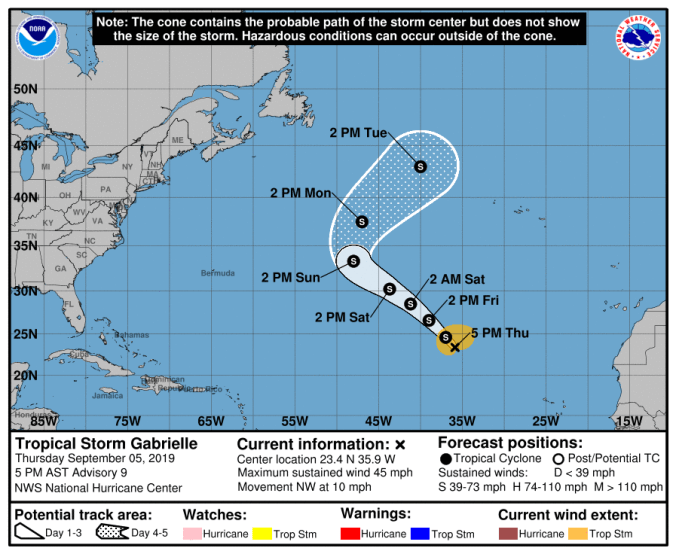 Meanwhile, as Hurricane Dorian creeps along the eastern coast of the United States, Tropical Storm Gabrielle is forecast to remain a tropical storm.
The storm is moving northwest at 10 mph. It’s expected to make a turn toward the northeast sometime Sunday or early Monday, away from the United States.
And finally, Tropical Storm Fernand is only a memory. It dissipated over the rugged terrain of Mexico yesterday.

I don’t understand this map…. Where’s the sharpie?
>
LikeLike