
HOLT, Fla., Aug. 20, 2020—A second tropical depression formed in the Caribbean Sea earlier today.
The tropical wave located in the western Caribbean strengthened into Tropical Depression 14 with 35 mph winds.
It’s moving west near 18 mph. A turn west-northwest, then northwest is forecast for Friday through Sunday.
The center of the system is expected to cross the Yucatan Peninsula Saturday night and move into the south-central Gulf of Mexico Sunday, according to the National Hurricane Center.
Slight strengthening to tropical storm strength is expected sometime tomorrow before the center reaches Honduras and Nicaragua, with little change thereafter until it re-emerges over the Gulf of Honduras.
Low wind shear and warm sea surface temperatures should then support further intensification up until it reaches the Yucatan Peninsula.
The system could be near or at hurricane strength when it reaches the Yucatan Peninsula late Saturday, according to the NHC.
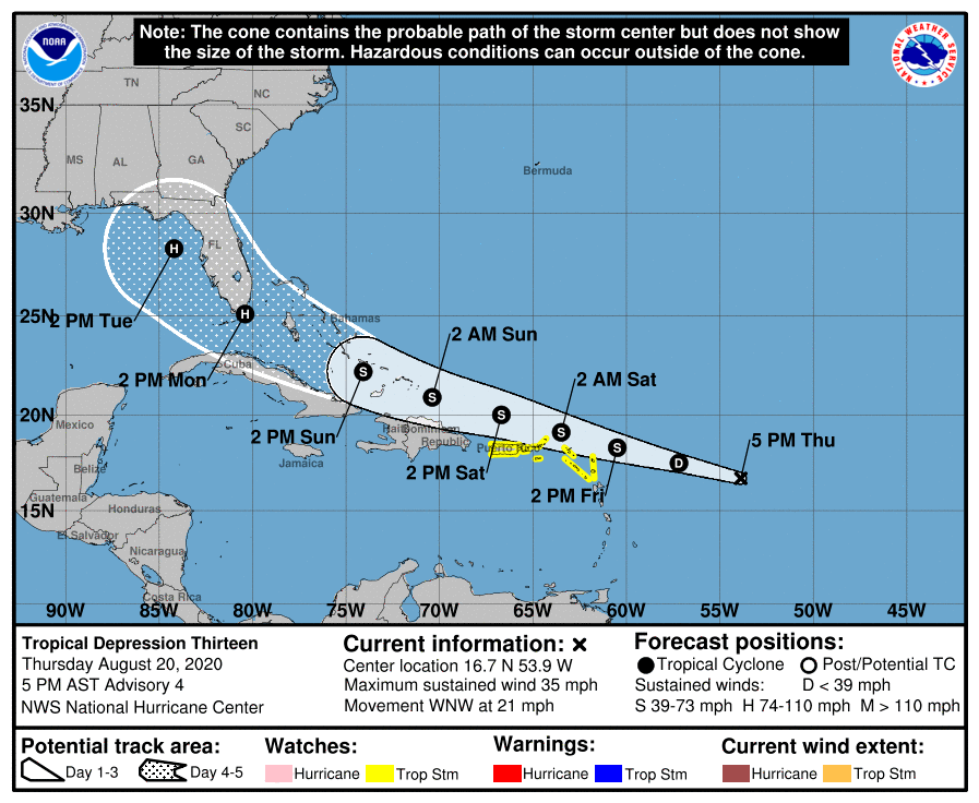
Tropical Depression 13 is keeping the NHC guessing on strength and direction.
Although the depression has changed little in strength since it formed yesterday, the overall environment ahead of the system favors gradual strengthening, according to the NHC.
The depression is forecast to remain over warm water and in an area of light-to-moderate wind shear.
Most of the guidance suggests a little more favorable upper-level wind pattern once the system is north of the Greater Antilles, but a track farther south means more land interaction which increases the uncertainty in the forecast strength of the system.
Bottom line: It’s still too early to know the strength and direction if this system at this time.
NHC forecast
