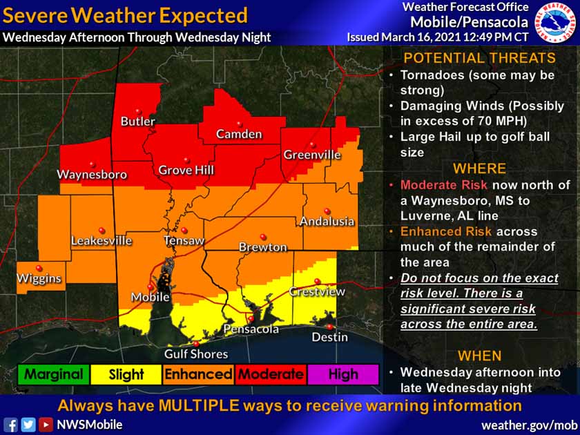
HOLT, Fla., March 16, 2021—All signs are pointing to a volatile severe weather setup for tomorrow according to the National Weather Service in Mobile.
The NWS has identified a significant severe weather risk across the entire area Wednesday afternoon through Wednesday night and into Thursday morning.
A more organized line of storms developing ahead of a cold front moving through is expected to produce severe weather with supercell thunderstorms capable of producing tornadoes—a few which may be strong (EF2+)—golf-ball-size hail and damaging winds up to 70 mph.
Isolated supercells are expected inland across southeast Mississippi and southwest Alabama Wednesday afternoon. A line of severe weather then moves through the region during the evening into the overnight hours.
According to the NWS, there could be a lull or lulls in storm activity, especially in advance of the main line of storms Wednesday night.
As the day progresses tomorrow, low-level southerly winds will increase by mid morning and persist through the afternoon into Wednesday night.
A wind advisory will be in effect from 10 a.m. Wednesday through 7 a.m. Thursday.
The western Florida panhandle can expect the systems to reach here between 1 and 6 a.m. Thursday.
The severe weather threat will gradually end across eastern areas around or just after sunrise Thursday morning.
Residual rain showers with some potential thunderstorms will still be possible on Thursday morning.
By Thursday afternoon, all storm chances will have moved out of the region with dry conditions remaining through the rest of the period.
National Weather Service forecast
