 HOLT, Fla., Sept. 7, 2018—The tropical waves identified by the National Hurricane Center earlier this week have become tropical depressions along with a third new area of low pressure in the Atlantic.
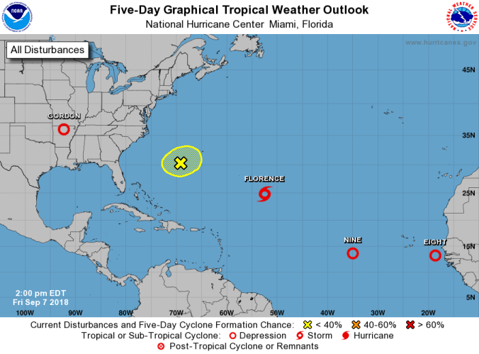
 The system in the far eastern Atlantic Ocean closest to Africa was upgraded to Tropical Depression Eight by the NHC in its 5 p.m. tropics update.
Moving toward the west near 10 mph, the system is expected to continue on a west-to-west-northwest motion with a gradual increase in forward speed during the next 72 hours.
Maximum sustained winds are near 35 mph with higher gusts.
Strengthening is forecast during the next three days or so and the depression is expected to become a tropical storm tonight.
Light-to-moderate wind shear is expected to allow steady strengthening and the depression is forecast to become a hurricane in the next two-to-three days.
 The tropical system located between the Lesser Antilles and the Cabo Verde Islands was also upgraded to a tropical depression at the 5 p.m. update.
Tropical Depression Nine is stationary and little motion is expected through tonight, according to the NHC.
A westward motion with an increase in forward speed is expected this weekend and early next week.
Maximum sustained winds are near 35 mph with higher gusts and little change in strength is expected during the next 24 hours. However, gradual strengthening is forecast late this weekend and early next week.
In addition to the two newly formed tropical depressions, a new area of low pressure located a few hundred miles west of Bermuda was identified by the NHC.
Development of this system, if any, should be slow to occur during the next couple of days before environmental conditions become unfavorable, according to the NHC.
This system is expected to move little during the next few days and formation chances during the next five days is low at 20 percent.
 Meanwhile, hurricane models are again indicating Tropical Storm Florence is headed toward the east coast of the United States.
Florence is moving toward the west near 8 mph and this general motion is expected to continue for the next couple of days.
A west-northwest motion with an increase in forward speed is expected during the early-to-middle part of next week.
Little change in intensity is expected during the next day or so, but re-strengthening is forecast during the weekend and Florence could become a hurricane again by Sunday, according to the NHC.
