The National Hurricane Center is watching tropical storm activity in the Atlantic Ocean.
HOLT, Fla., Sept. 20, 2018—The National Hurricane Center is monitoring four areas in the Atlantic Ocean for possible tropical development during its five-day forecast period.
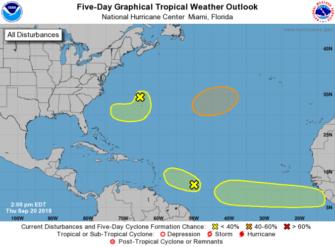
Satellite imagery shows showers and thunderstorms associated with the westward-moving tropical wave located about 750 miles east of the Windward Islands have become less organized during the last several hours.
There is no evidence of a surface circulation at this time and a combination of dry air and strong upper-level winds are expected to make development of this system unlikely while it moves west at 10-to-15 mph.
Formation chance through the next five days is low at 10 percent.
The second area the center anticipated forming has become a non-tropical area of low pressure with gale-force winds located about 150 miles north of Bermuda.
This system is moving south-southeast at about 15 mph.
Although there are some signs of organization, dry air and strong upper-level winds are expected to limit development of this system during the next couple of days.
However, conditions could become a bit more favorable for this low to gradually acquire some tropical characteristics early next week as the low moves south and then drifts west-to-southwest of Bermuda.
For now, formation chance through the forecast period is at 20 percent.
A third non-tropical low-pressure system is forecast to develop by Friday night over the central subtropical Atlantic Ocean between Bermuda and the Azores.
Conditions are expected to be favorable for this low to develop into a subtropical or tropical storm late this weekend or early next week while the low meanders over the central Atlantic Ocean.
Unlike the other two systems, this low has a 50 percent chance at development during the next five days.
Finally, a tropical wave is forecast to slide off the west coast of Africa by Saturday.
Some slow development of this system is possible early next week as it moves quickly westward across the low latitudes of the eastern tropical Atlantic Ocean.
For now, it’s chances of further development is at 20 percent.
National Hurricane Center forecasts
