 HOLT, Fla., July 10, 2019–The National Hurricane Center has designated the low-pressure system Invest 92 as Potential Tropical Cyclone Two.
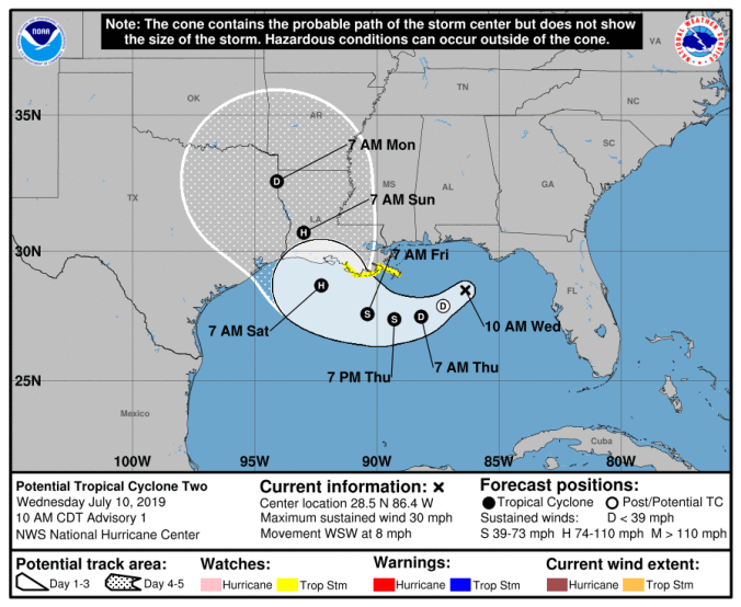
That’s a precursor to what is forecast to become Hurricane Barry, which should become a tropical depression sometime in the next 24 hours, according to the NHC.
Tropical storm and surge watches have been issued along the east-central Louisiana coast. Additional tropical storm or hurricane watches may be initiated later today or tonight for the remainder of the Louisiana and upper Texas coasts.
Moving west-southwest at 8 mph, the system is expected to turn west Thursday and northwest toward the Louisiana coast Friday.
The combination of low wind shear and warm sea surface water temperatures is ideal for storm intensification, according to the NHC.
Strengthening during the next 72 hours, the disturbance is forecast to become a tropical depression Thursday, a tropical storm Thursday night and a hurricane Friday.
This will be the first hurricane of the season. The first tropical system 2019 was Subtropical Storm Andrea in May before the official June 1 start of the season.
This system has potential to produce heavy rainfall through early next week. As a general rule, slow-moving storms, such as Hurricane Harvey in 2017, bring heavy rain and potentially devastating flooding.
For this area, rain is in the forecast through Sunday with an 80 percent chance Thursday and Friday, and a 70 percent chance Saturday. Cloud cover will keep the temperatures in the high 80s for the week.
