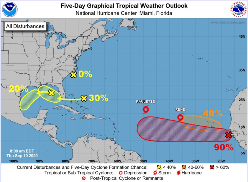
HOLT, Fla., Sept. 10, 2020—The National Hurricane Center has multiple areas to watch this Sept. 10 as the hurricane season reaches its climatological peak.
Tropical Storm Paulette is now forecast to strengthen into a category 1 hurricane late this weekend or early Monday with the possibility of growing stronger, according to the NHC.
While it is forecast to remain at sea, the five-day forecast puts Bermuda directly in its path.
Tropical Storm Rene is also forecast to strengthen into a category 1 hurricane this weekend; however, it’s expected to weaken back to a tropical storm early next week.
Rene is expected to remain at sea and track east of Bermuda.
The low pressure area off the Carolinas isn’t expected to produce much more than rain.
Further east across the Atlantic Ocean, the tropical wave the NHC has been expecting is finally over the Atlantic.
Formation chance is now at 90 percent.
A tropical depression is forecast to develop this weekend or early next week while the system moves generally westward across the eastern and central tropical Atlantic.
Along with that wave, another tropical wave is forecast to emerge off the west coast of Africa this weekend.
Environmental conditions are favorable for development and a tropical depression could form over the far eastern Atlantic early next week while the system moves slowly westward, according to the NHC.
This already has a 40 percent chance for development.
Closer to home, a low pressure is producing disorganized showers and thunderstorms centered a couple hundred miles northeast of the Central Bahamas.
This system is forecast to move westward, crossing the Bahamas and Florida tomorrow and move into the eastern Gulf of Mexico during the weekend.
Some development is expected and the NHC has given it a 30 percent chance.
Finally, another low pressure system developed over the northeastern Gulf of Mexico.
Some slow development of this system is possible while it moves westward then southward over the northern and western Gulf through early next week.
For now, it’s not expected to impact the Gulf coast. It has a 20 percent chance to develop further.
Should one of these systems become a tropical storm, the next name on the list is Sally, then Teddy.
With only four more names on the 2020 hurricane list and two-and-a-half more months of hurricane season, it’s likely the NHC will have to turn to the Greek alphabet for names after Teddy, Vicky and Wilfred are used.
Staff and National Hurricane Center forecasts
