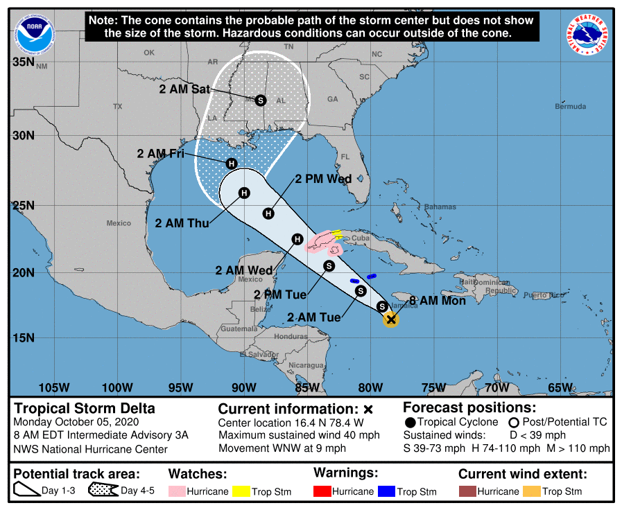
HOLT, Fla., Oct. 5, 2020—Tropical Depression 26 has now become Tropical Storm Delta.
Tropical Storm Delta is expected to strengthen into a hurricane by the time it moves near or over Cuba.
Maximum sustained winds have increased to near 40 mph with higher gusts.
Delta is forecast to move into the southeastern Gulf of Mexico Tuesday night or early Wednesday and approach the northern Gulf Coast late this week as a possible category 2 hurricane.
However, according to the National Hurricane Center, the steering flow pattern becomes a little complex on days two through three of the forecast due to expected interaction with Tropical Storm Gamma or its remnants, which could result in a sharp westward jog, after which a sharp turn back toward the northwest could occur.
Model guidance is in fairly good agreement that the cyclone will make a sharp northward turn around day four or so, according to the NHC.
After that, acceleration toward the north-northeast or northeast is anticipated somewhere between Louisiana and the western Florida peninsula.
Although there is large uncertainty in the track and intensity forecasts at these timeframes, there is a risk of dangerous storm surge, wind and rainfall hazards along the coast from Louisiana to the western Florida panhandle, according to the NHC.
Meanwhile, Gamma is forecast to make a second landfall on the Yucatan Peninsula tomorrow or Wednesday.
An Air Force reconnaissance mission found Gamma to be weaker and further weakening is expected during the next few days.
With 25 named storms so far this year, 2020 is the second most active hurricane season on record.
